Written by Eratosthenes Centre of Excellence (ECoE)
Agricultural water demand is increasing due to rising food production required to meet the dietary needs of a growing global population. At the same time, the ongoing climate change and the unsustainable water use are placing additional pressure on the already limited water supplies. Farmers, water managers and policymakers around the world continue to face challenges in addressing the growing water shortages. In this context, satellite-based Earth observation has emerged as a valuable tool for monitoring and managing water resources.
How water scarcity impacts agricultural sector
Approximately 70% of global freshwater withdrawals are consumed by the agriculture sector. As water scarcity intensifies, food security is increasingly at risk, threatening the nutritional needs of the global population. Monitoring water balance components is therefore essential for improving our understanding of hydrological processes and agricultural water demand. Traditional monitoring approaches rely on agrometeorological sensors and in-situ field observations. While these methods have proven effective, they are limited in spatial coverage and often lack the ability to capture variability across large areas. To address this gap, Earth Observation (EO) has emerged as a transformative tool, providing frequent, large-scale, and near real-time information on crop stress and water use. Consequently, EO now plays a key role in supporting agricultural water management.
Earth observation for water stress monitoring
There are several indicators of water scarcity that can be obtained from satellites:
- Satellite technology in soil moisture detection
Synthetic Aperture Radar (SAR) and microwave sensors can penetrate the soil and provide an estimation for soil moisture levels. With this approach, drought areas can be identified and decision-making regarding irrigation can be performed. Indices developed such as Normalized Difference Water Index (NDWI) can be used to monitor water changes in both vegetated areas and water bodies.
- Crop health monitoring
There is several vegetation indices developed that can be used to describe crop status. Indices such as Normalized Difference Vegetation Index (NDVI) and Enhanced Vegetation Index (EVI) through their reflectance in the visible and near-infrared portion of the electromagnetic spectrum can detect crop stress. Since water availability strongly influences plant health, variations in these indices can also serve as indicators of water scarcity. A decline in NDVI or EVI values often reflects reduced soil moisture or drought conditions, making them valuable tools for monitoring crop response to water stress and assessing the impacts of water scarcity on agricultural productivity.
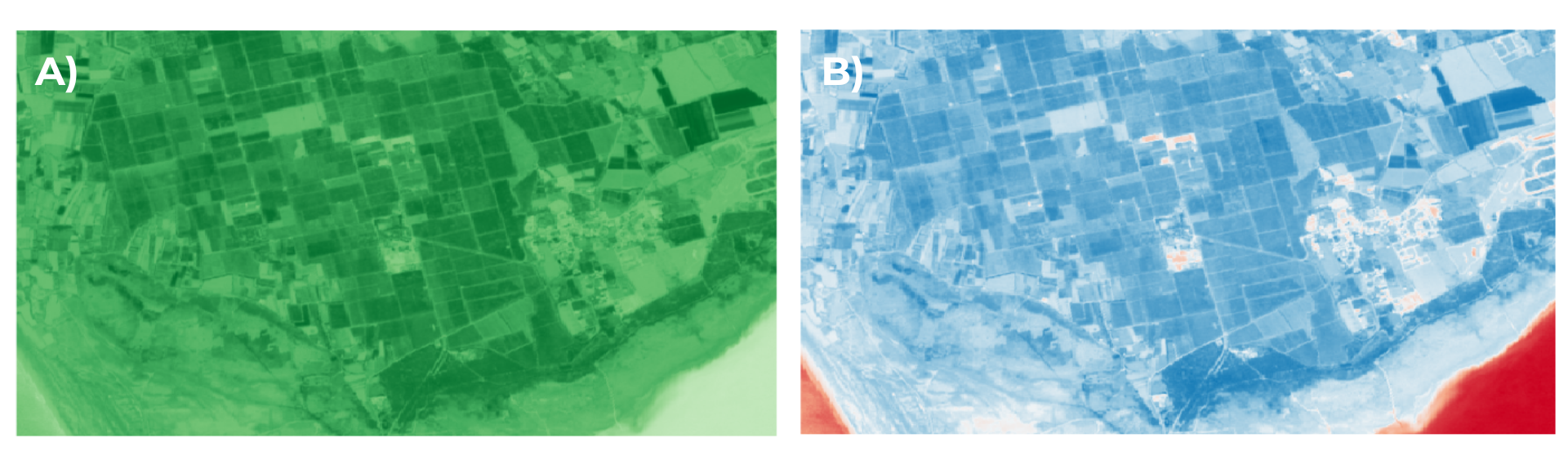
Figure 1. a) NDVI, b) NDWI obtained from Sentinel 2 satellite data
- Evapotranspiration monitoring
Satellite data provide information on soil water and vegetation state which can be used to derive crop water requirement estimates. Satellite images provide large-scale, continuous information that supports informed water-management decisions. For example, the MODIS (Moderate Resolution Imaging Spectroradiometer) instrument, part of NASA’s Earth Observing System (EOS), generates the MOD16 global evapotranspiration product, which quantifies land surface water and energy fluxes. These datasets are valuable for assessing regional water availability and evaluating how climate variability and land-use change influence ecosystem water demand.
.
Earth Observation application in agriculture
Earth observation data can support decision-making for precision irrigation scheduling, enabling significant water savings. Moreover, EO data are capable of providing early drought warning information, which is crucial for taking proactive measures to minimize economic losses in the agricultural sector. Additionally, EO contributes to fair and sustainable water allocation by informing basin-level planning across farming, industry, and local communities.
Conclusion
Limited water availability in agriculture is a global challenge that requires urgent attention, as it directly affects food production, farmer livelihoods, and long-term environmental sustainability. With climate change intensifying drought frequency and altering precipitation patterns, traditional water management practices are increasingly insufficient. EO provides valuable spatiotemporal information on water balance components and plant–water dynamics at field, regional, and basin scales. By offering continuous monitoring of parameters such as soil moisture, evapotranspiration, vegetation health, and surface water extent, EO enhances the capacity to detect water stress early, optimize irrigation scheduling, and assess crop water requirements more accurately. In doing so, EO strengthens and complements existing water resource management approaches, supporting more informed decision-making for both policymakers and farmers, and promoting the sustainable use of limited freshwater resources.